


Revaluation for Dummies: Understanding Your New Assessment
- Wednesday, 04 June 2014 08:46
- Last Updated: Monday, 09 June 2014 22:26
- Published: Wednesday, 04 June 2014 08:46
- Joanne Wallenstein
- Hits: 9066
 Even after Tyler Technologies held a meeting to clarify the process behind Scarsdale's village-wide revaluation, questions abound. Greenacres resident, statistician and certified actuary Michael Levine has studied Tyler's model and agreed to explain it to those of us who don't have an advanced degree in statistics. Here are answers to two questions that get to the heart of the matter.
1) What were the key factors that were used in the model – i.e. Which had the most weight?
Before I answer this, let me explain that the "model" fits into a bigger process. My understanding of this process is based on what I have pieced together, plus what Tyler said at the May 29 meeting. My analysis is limited to single family residences. The process basically has four steps
(1) Develop land values based mainly on neighborhood and lot area (acreage), with some adjustment for things like busy streets.
(2) Create the model and calculate model estimates for every property.
(3) For every property, identify five (or sometimes four or three) recently-sold properties as comparable sales ("comps").
(4) Based on the comps, adjust the value (up or down or no change) from the model estimate.
So, now I am explaining item (2). The model is a mathematical formula. A simple example of a model/formula – one that they did not use -- would be
Value = (Area in Square Feet) * (380 per SF) + 350,000.
The "model value" for a 3,000 SF house would = (3,000 * 380) + 350,000 = 1,490,000.
Where would they have gotten the $380 and the $350,000? By looking at recent sales for all of Scarsdale and using a mathematical technique called "ordinary least squares regression". The actual sales would have been at all different "per square footages". The model value will be over for some and under for others, but the theory is that this is the best formula for explaining the sales prices if you limit yourself to formulas that involves a factor per SF and a constant.
Obviously, square footage is not the only thing that should matter. The acreage should obviously matter. There are a whole list of characteristics that a common sense person would think could matter, such as location, number of bathrooms, existence (or not) of central air, age of the property, etc. Some important subjective considerations are
• The quality of construction – materials and workmanship – which is intended to be captured in the "grade" and "grade adjustment" characteristics. Grade is from A (Excellent) to E (Minimum). The Grade Adjustment is a percentage, such that the average for any grade level is 100, and it could up (e.g., to 90) or down (e.g., to 110).
• The quality of maintenance – the amount wear-and-tear and so forth – which is intended to be captured in the "overall condition" characteristic. Overall Condition is from 1 (Poor) to 5 (Excellent)
You can learn more about these definitions by looking at the New York Assessor's Manual, which is posted on the village website.
With many characteristics that could contribute to value, the math of the regression calculation becomes more complicated, but the goal is the same – find a formula that expresses a value as factors applied to characteristics. Also, there is some art in deciding which factors to use.
With this as background, I would say that the Tyler model for Scarsdale – the results of their regression -- heavily uses land value (which basically reflects acreage and neighborhood) and square footage, which make sense. Grade and grade adjustment are also very important. Condition is important, and there are separate square foot measures for finished basements and rec rooms. There is an addition if you have an inground pool.
The Tyler formula does not explicitly include number of bathrooms or bathroom quality or the existence of central air, for example. If you have 3.5 baths in and they incorrectly said 5.5, it would not have had any impact of their model's calculation of your value
I personally think the model is simply too sensitive to the refinements of the grade adjustment, caused by additional mathematical nuances factors that are beyond what I can explain here. I recently saw a case where changing a "B 115%" to a "B 110%" on a smaller-sized housed caused a $60,000 impact. I do not think the real buying market would discern these differences (as compared to number of baths), and this is supposed to be about real market value.
But even if the model can be mathematically justified, my biggest complaint about all of this is that the Scarsdale taxpayers were never, ever informed about the importance of grade/grade adjustment, or even that it would matter at all.
• Back in 2012, the press releases and flyers assured us that, after the physical inspection, "[a] letter detailing the physical attributes collected and to be used in the valuation, referred to as a data mailer, will be sent to you." (emphasis added.) My letter showed things like acreage, square feet, overall condition, and number of bedrooms and told me I should indicate any changes. The letter did not disclose grade/grade adjustment.
• A taxpayer who looked at the Property Inquiry on the village website any time up until a few weeks ago would not have seen grade/grade adjustment.
• The formula was not made public until I figured it out from a FOIL request and submitted it to the Board of Trustees on May 27.
• Thus, a taxpayer trying to contest a valuation in an informal meeting would never have known their own grade/grade adjustment, and would never have known that it mattered.
It is as though your boss gave you your "objectives" for the year, and you agreed to them, and then at bonus time your boss told you that you got a bad bonus because you did not do well on some objective that was important in the bonus calculation but that you had no idea about.
2) How were the neighborhoods of Scarsdale weighted or ranked in terms of land value?
I am interpreting this question as asking about the results – the "ranking" and not the math or theory Tyler went through to do it.
As background, I should note that land value enters the valuation in two different ways. There is the "official" land value that appears on the formal assessment roll along with the total value. That value is then used within the model formula. The model does not just add 100% of this amount. So, a second way you could measure land value is in the sense of how it works through the model, and thus how much it actually ends up adding to your total value. I will call this the "contribution to total" land value.
Tyler's calculation of official land values appears to have been done early on. It seems they ended up developing 14 "neighborhood codes" – two for Greenacres and three each for the other elementary school codes. The village website now has the map that shows the neighborhood codes.
Tyler published formulas for official land values. The results are calculated and presented in this graph, and this shows you the relative ranking of neighborhoods
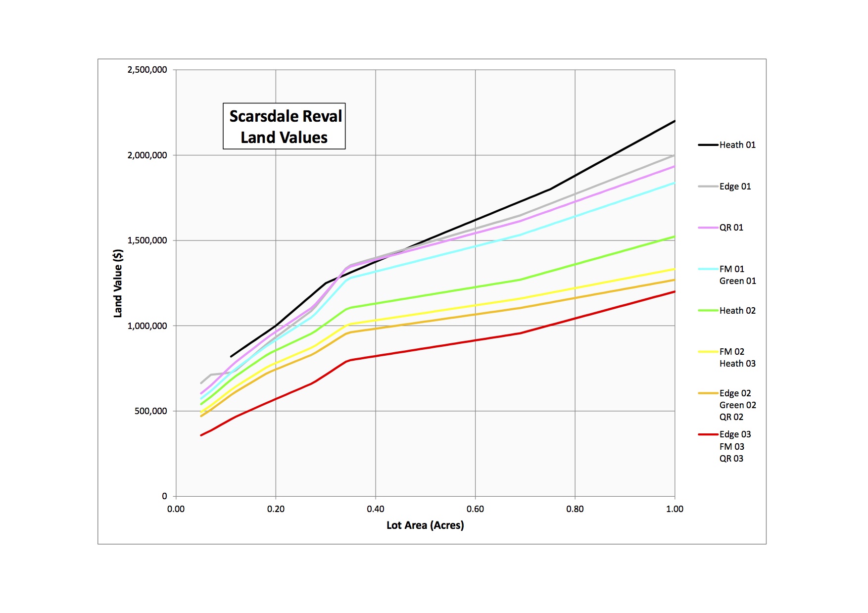
You will see that there are rally only eight distinct lines or curves, with some neighborhoods sharing the same curves.
I should also note the following.
• These lines are what I call the "primary" curve for each neighborhood. I would say the majority of homes have values on these lines, but there are secondary and tertiary curves within [most] neighborhood – lines that are about $50,000 lower than the primary. These lines will have the houses that are on busy streets, or very close to busy buildings or other factors that reduce value.
• This graph only goes out to one acre. If the graph went out further, you would see the Heathcote 01 (black) line going up more steeply, compared to the others. At 2.0 acres, Heathcote 01 is at $3.6 million and Fox Meadow 01/Greenacres 01 (blue) is at about $2.34 million. Edgewood 01 (a few houses on Taunton Rd) and Quaker Ridge 01 (Brittany Close) would theoretically be in between, but they do not actually have any properties at the larger land sizes.
Now, regarding the "contribution to total" land value. The Tyler model formula includes 98.97% of the official land value, plus or minus an amount that varies by neighborhood, as follows.
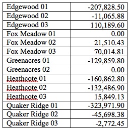
In other words, Tyler has concluded on some basis that the official land value is not a perfect indication of a neighborhood's contribution to total value. This slightly shifts the ranking of the neighborhoods, especially at the lower lot sizes. Fox Meadow 01 has the greatest land contribution to value for lot sizes up to 0.61, with Heathcote 01 having the greatest value at larger lot sizes.