


Trustees Review Proposals for Stormwater: See Where They May Store the Runoff!
- Thursday, 17 July 2025 13:02
- Last Updated: Monday, 28 July 2025 09:23
- Published: Thursday, 17 July 2025 13:02
- Joanne Wallenstein
- Hits: 2556
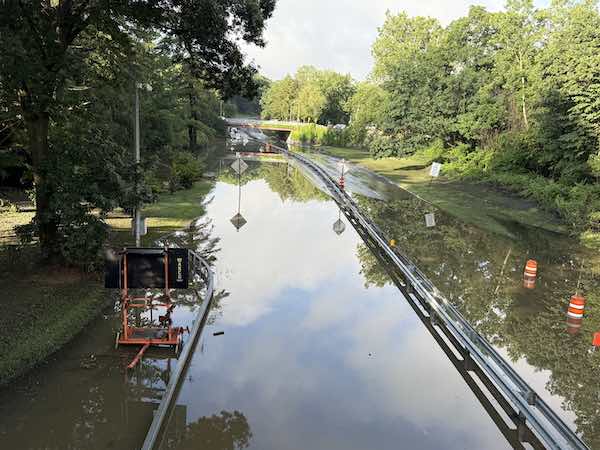 Bronx River Parkway, July 15, 2025Though Scarsdale was spared the worst in an intense rainstorm that inundated the region on July 14, 2025, the flooding in surrounding areas was a reminder of the ever-present risks posed by stormwater in Scarsdale.
(Updated July 28, 2025) For as long as Scarsdale10583 has been published, Trustees have been reviewing proposals to mitigate flooding in several low-lying areas of town. And just one day after the storm, Scarsdale Village Trustees again held a work session to review the status of several proposed projects, some of which are quite large.
At the meeting were consultants from two firms who were selected to analyze and propose plans to alleviate flooding: Jim Moran of H2M and John Ruschke of Mott MacDonald. The two presented options for reducing flooding near George Field, on Cushman, Willow and Sheldrake Roads, on Brite Avenue, Chesterfield Road and Fox Meadow Road and in the Sheldrake River watershed on Oneida, Cayuga, Canterbury, Catherine and Mamaroneck Roads.
Superintendent of Public Works Jeff Coleman reviewed work currently in process. He said that new culverts for Catherine Road are currently being designed. Once the design is complete, the Village will get bids and construction should begin in a couple of months. He said this work is being funded largely by a 2024 grant from FEMA.
Also in design is a culvert on Griffin Avenue that lies between Scarsdale and the Village of Mamaroneck. Therefore, Scarsdale would split the cost with Mamaroneck and they are hoping to get a grant to cover the expense.
George Field Park
Scarsdale built a seven acre retention pond on George Field Park in 2013. At the time this was one of the largest wetlands areas in Westchester County, able to hold water at depths of up to three feet. Though the project did much to improve water flow, a study in May 2022 found that more could be done to prevent flooding on Greendale Road, Oxford Road, Cambridge Road and Rugby Lane.
On Tuesday, H2M presented several proposals and their associated Benefit Cost Analysis (BCR) a calculation that determines the future risk reduction benefits of a mitigation project and compares those benefits to the costs. The higher the reduction in risk to the highest number of homeowners, the higher the BCA. FEMA will not fund any projects with a BCR under 1.
Moran made several proposals for George Field and Cooper Green (opposite the police station.)
The first involved installing 1,645 feet of piping, 10 manholes and 4 catch basins and replacing the existing catch basins and manholes. This would decrease the runoff entering the trunkline between George Field Park and Cooper Green, reduce flooding in a 10-year storms and provide substantial benefits in a 25-year storm. The estimated cost of this work is $2,251,600 and the BCR is .52.
Another option is to replace the control structure that discharges water into the pipe at Oxford Road, to elevate a portion of Greendale Road to prevent flooding and to install two new retaining walls along the southern and eastern portions of the pond to prevent it from over-topping during a 10 year storm. The BCR of this project is .12.
A further option is to do both projects which combined would have a BCR of .32. The total cost for construction is estimated at $4.1mm and the total project cost with project management and design fees would be $5.4mm.
Cushman, Willow and Sheldrake Road
This area, which encompasses water run-off from Cushman, Willow, Garden and Sheldrake Roads has been the source of years of complaints from residents. The area surrounds the water tower and is frequently flooded during rainstorms. According to the consultant, the existing drainage system does not have sufficient capacity to convey water from a two-year storm.
The consultants provided four alternatives and it was not clear if some or all of these would be undertaken:
The area defined as Cushman West, starts at the intersection of Mamaroneck Road and Cushman Road and ends at the sedimentation chamber at the intersection of Cushman Road and Willow Lane.
For that segment Moran proposed to install 2,040 feet of new drainage infrastructure, replacing seven existing catch basins and installing 8 more to capture runoff. At a cost of $1.4mm this would provide a higher level of collection and conveyance and reduce runoff.
At the north end of Cushman Road, bordering White Plains, there has been significant flooding as water from Cushman, Willow and Garden Roads converge there before entering a stream.
The consultants report, “There is an open channel that runs around 105 Cushman Road and enters an 18” closed drainage pipe via a concrete headwall that is located adjacent to 105 Cushman Road. The closed system then runs south towards Cushman Road, where the pipe increases in size to a 30”x30” stone culvert that crosses underneath the road and discharges into the existing sedimentation basin.”
In order to address the issue, Moran recommended replacing the existing damaged 18” drainage pipe with a 24” pipe, and removing and replacing the existing catch basin there. This would improve the flow, reduce ponding and flooding and repair the pipe. The cost of this work is estimated at $91,200 and has a BCR of .18
A third project, estimated to cost $759,700, would remove and replace piping along Cushman and Garden Roads and Varian Lane. Four existing catch basins would be removed and replaced and six new catch basins and one manhole would be installed. The impact would be to replace damaged pipes and reduce ponding. This work has a BCR of .2.
A larger project, estimated at $3,347,700 would enable the area to handle 2, 10 and 25-year storms by increasing the size of the piping to “increase flow capacity in the storm network and mitigate flooding during heavy rainfall. The BCR of that work is .21.
The consultants include that the greatest benefit for the money would be to do the improvements on Cushman Road West and North. See the report here:
Fox Meadow Project
John Ruschke of Mott McDonald then presented proposal for projects in Fox Meadow and the Sheldrake River Basin.
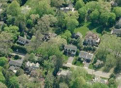
The Fox Meadow study was to investigate flooding concerns along Fox Meadow Road, Brite Avenue and Chesterfield Road, due to the suspected insufficient capacity of the existing systems. Currently the existing drainage systems along Chesterfield Road and Fox Meadow Road and the low-lying areas around Brite Avenue experience frequent flooding due to insufficient capacity. The consultants said the existing drainage system for the 155 acre site has less than a 2-year storm capacity and includes a combination of open channels and culverts that meander through residential properties.
The study recommends spending $2.6 mm to construct a new storm sewer system in that area.
Here is the description:
Construct a new supplemental storm drainage system along Fox Meadow Road, Chesterfield Road and Brite Avenue using pipes ranging from 42” to 60” in diameter that can withstand a 100-year storm. The existing open channel will remain active. The report says, “The new system would be designed to convey the 100-year storm event and would be designed to maintain a trickle flow into the existing open channel drainage system.”
Since the project affects so many homes it has a BCR of 1.1 and might be eligible for FEMA funding.
Sheldrake River Flood Mitigation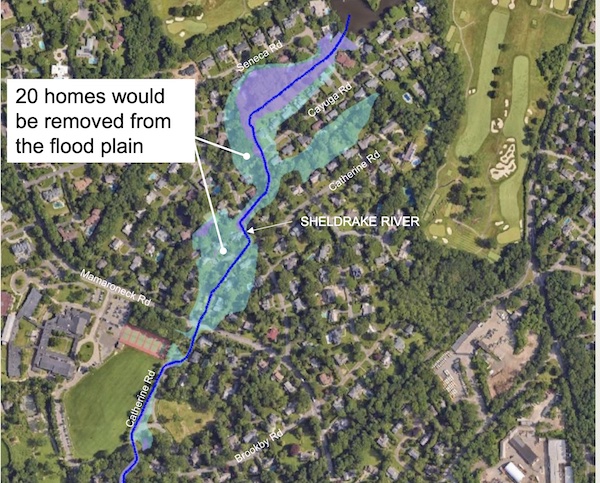
This is a huge project involving a 700-acre watershed. The project would relieve flooding on a large swath of homes across the street from Scarsdale Middle School that were originally built in a FEMA flood plain. Since it is a massive project, the consultants have not given an estimate of proposed costs, but here is a summary of what they are suggesting:
Replacement of the two culverts at Catherine Road adjacent to the middle school.
Replacement of a culvert on Cayuga Road.
Installation of a ten foot by four foot bypass culvert to bypass flows from Cayuga Road and send them downstream to the middle school athletic filed.
Construct a large underground detention structure underneath the SMS athletic fields. This would require the cooperation of the Scarsdale Schools as the field is their property. Consultants estimate the underground facility would be a 300 x 250 foot structure buried ten feet underneath the field.
Ruschke said, “At this point it shows that we would get significant benefits – we are still refining this. It is massive. We are looking at different types of materials. It is probably a $5 mm plus project and the middle school is not our land – it belongs to the school district. But there are substantial benefits.”
Following the discussion, Trustees posed a series of questions about the benefits of each project. Asked about the timeline, Jeff Coleman, Superintendent of Public Works said, "The next step is to speak with Westchester County to determine if any of the projects could fit into the County Flood Mitigation program. If so we will make formal application for those projects." See more here: