


Trustees Consider Plan to Alleviate Flooding in Sheldrake Watershed
- Thursday, 18 July 2024 11:43
- Last Updated: Tuesday, 24 September 2024 07:35
- Published: Thursday, 18 July 2024 11:43
- Joanne Wallenstein
- Hits: 3141
 What’s going on with plans for improving drainage in Scarsdale?
One of the big ticket items in this year’s budget was spending to relieve flooding in many troubled areas of the Village -so on Tuesday July 16, the Mayor called a work session to review the progress of the Department of Public Works and Village Engineer on a long list of projects.
Before turning to an analysis of flooding across the street from the Scarsdale Middle School, Supervisor Jeff Coleman ran through a list of smaller projects that are now in process.
Among them are:
-Improvements at George Field Park, Cambridge and Rugby Roads to alleviate flooding are underway.
-On Cushman, Garden, Sheldrake and Willow Roads the Village is doing an analysis of the stream, creating a hydraulic model and is close to making some recommendations for work to be done.
- Replacement of a culvert at the end of Griffin Road.
-Stormwater remediation in Fox Meadow at the intersection of Ogden and Paddington Roads, and also on Chesterfield Road between Brite Avenue and Oak Lane.
-Library Pond where bidding for a project to address flooding at the pond will start in a month or so.
-Hutchinson River Stormwater: The Village is working with the City of New Rochelle on improvements to the Hutchinson River with the project to go out to bid in August and work to begin in the fall.
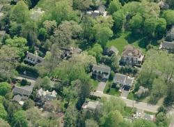
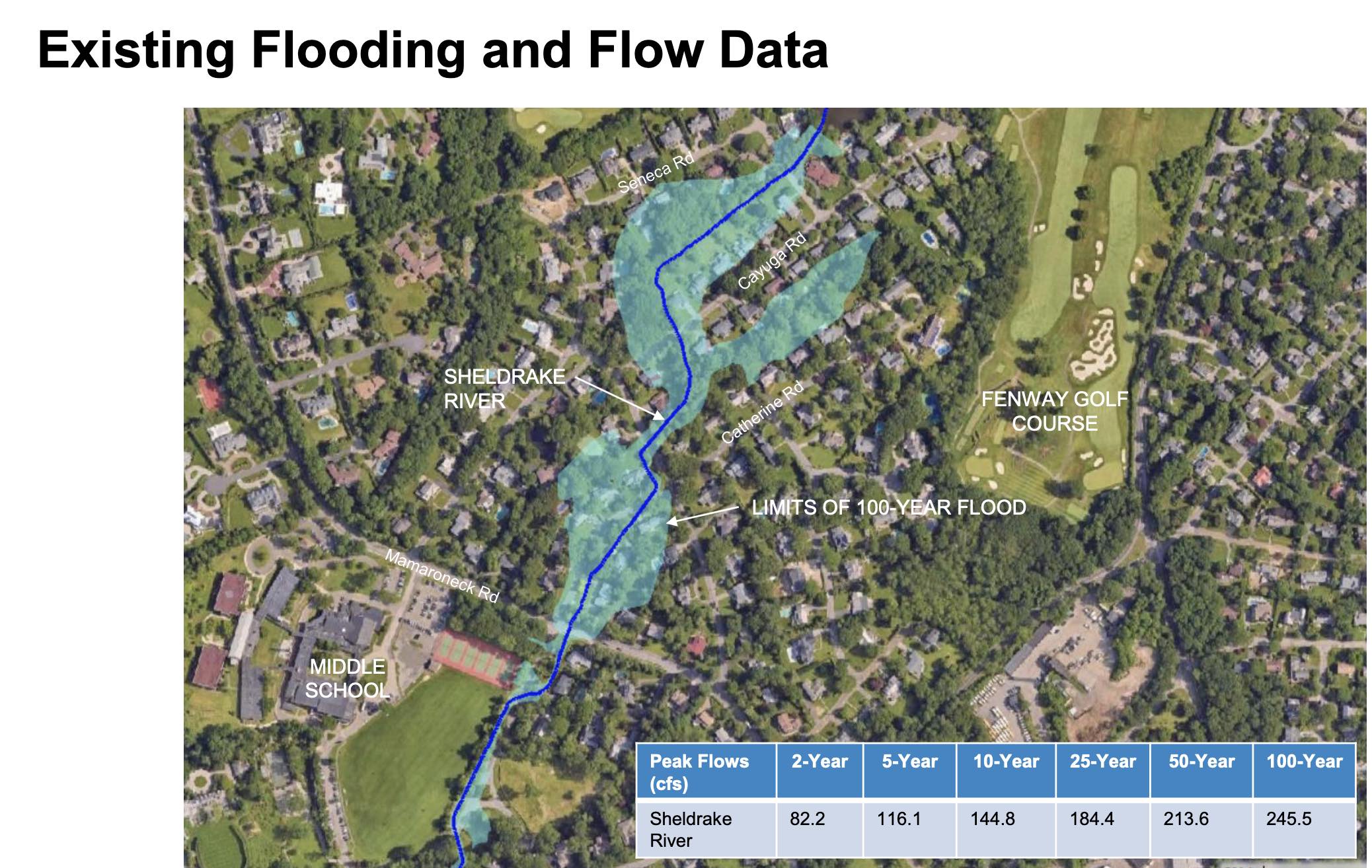
However, the reason for Tuesday’s meeting was to review possible solutions to extensive flooding in the neighborhood across from Scarsdale Middle School at Catherine, Leatherstocking, Oneida and Cayuga Roads. Coleman said this neighborhood “was one of the hardest hit,” and engaged engineering consultants to look for possible solutions. Residents have been lobbying the Village for more than a decade to do work to safeguard their homes which flood extensively when there is heavy rainfall. They estimated that the flooding affects about 20 homes which were built in a FEMA flood plain. Here is an article from 2012 on Scarsdale10583 discussing the flooding:
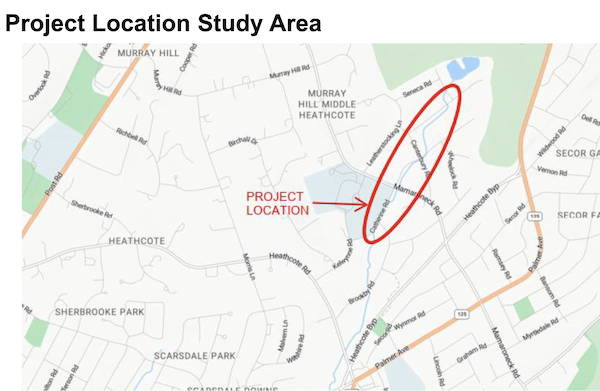
John Ruschke, an engineer with Mott McDonald explained that a 700 acre watershed of the Sheldrake River drains into this area causing substantial flooding on Catherine and Cayuga Roads. The engineer presented a study that examined three alternatives to significantly improve the situation, in what has been designated a FEMA flood plain.
The three alternatives were:
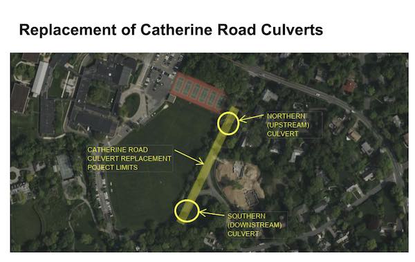
Replacement of Catherine Road Culvert: They looked at enlarging the culverts and lowering the channel between them. However, their analysis did not show that this would provide an improvement.
Second they looked at upstream drainage improvements and examined the effects of eliminating a 50 acre portion of the drainage area in the rear of properties on Catherine and Cayuga Road. They would create a bypass culvert and redirect the flow. However, this proposal was also found to have an Insignificant benefit. to removing 50 acres.
 Last, they analyzed the effect of a total replacement of the Cayuga Road culvert and the installation of a 10 foot by 4 foot bypass culvert that would run from Canterbury Road between Cayuga and Catherine Roads that will extend downstream in the vicinity of the middle school, just downstream of Mamaroneck Road with a replacement of the Cayuga Road culverts with a new 10’ wide by 4’ high culvert.
In this proposal, water flows would be redirected deposited at the middle school where retention basins may need to be installed under the fields. This would eliminate all the chokepoints and the bottle neck and should yield significant benefits.
Additional work needs to be done to determine the size of the culvert. Cost analyses will also be needed to determine how much it will cost to do the installation which will interfere with the water, gas and sanitary lines that run underneath Catherine Road.
In the discussion that followed trustees asked if the project would affect neighbors downstream. The Mayor asked if there are existing maps of Scarsdale’s stormwater infrastructure and the response was that there is not a complete map, but that the Village is working on building one as a part of the process of designing these projects. The Mayor said, “We have $6 million in this year’s budget for drainage improvements – would it help if we allocated some of that to mapping? Would that speed things up?”
A resident from Cayuga Road said, “It is not just backyard flooding – it affects our homes. We sustained $120,000 during Hurricane Irene and $100,000 during Ida – it is a significant amount of damage. Any fix you make will impact all of us. We have a vested interest in this project. Any small improvement that you make will benefit us.”
A doctor from Cayuga Road said, “The patient is dying, Scarsdale is not a wildlife preserve. The last storm cost me $200,000. Do you know which homes were flooded and to what degree? We are talking about people. You are disrupting people’s lives when you get 5 feet of water and stool in your basement. It disrupts our lives every time in rains. See who is being affected by the flooding – and where you can store the water.”
Supervisor Coleman assured him, “I appreciate that you are passionate about. But you are preaching to the choir – we are all looking for the same solutions. We are going to move the water downstream to the middle school. We need to analyze how much storage is needed.”
Asked how long it would take to get this done, Coleman said plans would need to be finalized by the end of the year. Then the Village would apply for grants which might take several years. So it did not appear this would be quickly.
As the project could cost millions to implement, one trustee asked if it might be best for the Village to take a few of the flooded homes by eminent domain rather than spend millions protecting them. This enraged one of the residents assumed that he would not receive fair market value for his home.
At the close of the meeting, Village Engineer Dave Goessl explained, “Scarsdale is surrounded by three watersheds, the Sheldrake River, Hutchinson River and Bronx River basins. We are shedding water to our neighbors.”
Discussions about alleviating stormwater inundation in flood-prone areas are taking place at the same time that the Planning Board is considering applications to build in more flood prone neighborhoods. On their agenda is construction of a new home over an area that was formerly a pond at 46 Lincoln Road. In addition, applicants are continuing to seek approval to build up to eight homes, with swimming pools, in a swampy watershed next to the water tower at 80 Garden Road.
Given the Village’s experience with allowing construction in wet environs, it’s not clear why the trustees don’t take measures to prevent future building in areas that have historically flooded.